GlobalSat BT-338, SD-502 and BC-337
1. Introduction
In today's world, more and more people are becoming dependent on their mobile devices to keep them in touch, no matter where they may be. One of the ever growing needs has been in navigation which has brought GPS devices to the forefront. With CDRinfo's expansion into mobile devices, GlobalSat has kindly offered us the opportunity to test several devices from their impressive product line. Let's start with some background information about GlobalSat, the company.
- Global Sat background
![]() Globalsat Technology was founded in May, 2000 with its head office and main factory located at the Far East Century Park in Taipei County, Taiwan. Globalsat Technology was established by a group of professional and experienced managers and engineers. The company vision is to bring the advanced wireless technology from UK Cambridge Park and US Silicon Valley to the global application industry through Taiwan's unique innovation technology.
Globalsat Technology was founded in May, 2000 with its head office and main factory located at the Far East Century Park in Taipei County, Taiwan. Globalsat Technology was established by a group of professional and experienced managers and engineers. The company vision is to bring the advanced wireless technology from UK Cambridge Park and US Silicon Valley to the global application industry through Taiwan's unique innovation technology.
 To achieve this vision, Globalsat Technology set up the "Globalsat College" within the company as the foundation building of hi-tech research and management for the innovation technology. The Globalsat College has successfully led the company to a learning organization, which was initiated and highly recommended by Professor Peter Senge from Massachusetts Institute of Technology.
Globalsat has been focusing on the effort on GPS, Bluetooth and mobile wireless communication technology during the past few years. As of this date, Globalsat has grown to the leading position as the designer, manufacturer and marketer in GPS, Bluetooth and mobile wireless communication products, and will continue the effort in the information and digital industry.
- What is GPS?
For those who don't know what GPS is, let's see what Wikipedia.org has to say:
"...The Global Positioning System, usually called GPS (the US military refers to it as NAVSTAR GPS - Navigation Signal Timing and Ranging Global Positioning System), is the only operational satellite navigation system.
Satellite Navigation Systems can be used for determining one's precise location and providing a highly accurate time reference almost anywhere on Earth or in Earth orbit. The accuracy of the GPS signal itself is about 5 meters (16 ft) as of 2005 and has steadily improved over the last 15 years. Using differential GPS and other error-correcting techniques, the accuracy can be improved to about 1 cm (.4 in) over short distances.
The GPS system is divided into three segments: space, control and user. The space segment comprises the GPS satellite constellation of at least 24 satellites in an intermediate circular orbit (ICO) . The control segment comprises ground stations around the world that are responsible for monitoring the flight paths of the GPS satellites, synchronizing the satellites' onboard atomic clocks, and uploading data for transmission by the satellites. The user segment consists of GPS receivers used for both military and civilian applications. A GPS receiver decodes time signal transmissions from multiple satellites and calculates its position by trilateration..."
Globalsat products support WAAS (Wide Area Augmentation System). It's a system of satellites and ground stations that provide GPS signal corrections, giving up to five times better position accuracy over standard GPS. A WAAS-capable receiver can give you a position accuracy of better than three meters, 95 percent of the time. You don't have to purchase additional receiving equipment or pay service fees to use WAAS.

WAAS satellite coverage is available only in North America. Other governments are developing similar satellite-based differential systems - Europe's system is the Euro Geo-stationary Navigation Overlay Service (EGNOS). WAAS receivers are compatible with EGNOS.
All the tested devices include the SiRF III chipset with the following specifications:
| Chipset: | SiRF Star III WAAS enabled |
| Frequency: | 1, 1575.42 MHz |
| C/A code: | 1.023 MHz chip rate |
| Channels: | 20 channel all-in-view tracking |
| Position Accuracy: | 10 meters, 2D RMS |
| ~ 5 meters, 3D RMS WAAS | |
| Velocity: | 0.1 m/s |
| Time: | µs synchronized to GPS time |
| Default: | WGS-84 Acquisition Time (Open sky, stationary) |
| Reacquisition: | 0.1 sec., average |
| Hot start: | 1 sec., average |
| Warm start: | 38 sec., average |
| Cold start: | 42 sec., average |
| Altitude: | 18,000 meters (60,000 feet) max. |
| Velocity: | 515 meters/second (1000 knots) max. |
| Acceleration: | Less than 4g |
| Jerk: | 20 m/sec |
| Protocol messages: | NMEA-0183 output protocol |
| Output format: | GGA(1sec), GSA(5sec), GSV(5sec), RMC(1sec),VTG(1sec) |
| Operating temperature: | -20° to 60° C |
| Humidity: | 5% to 95% Non-condensing |
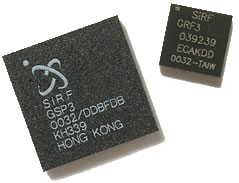
Looking at the SiRF III specs, we notice that the chipset is capable of receiving up to 20 channels (actually 12 maximum), has very low Hot/Warm/Cold start times and its accuracy reaches ~5m when WAAS mode is enabled.


