Bing Maps Rolls Out Enhanced Aerial and Street-Level Views
The new Bing Maps Beta adds a new viewing mode and an "application gallery" to further enhance its virtual perspective of the world, Microsoft announced Wednesday.
Microsoft previewed some new enhancements to its Bing search engine as part of its drive to break out of third place and become a serious contender to Google in search.
Bing Maps now offers a Streetside and enhanced aerial view, giving users the ability to explore what's around them from the street level or from the sky looking down.
The new Bing Maps incorporates several key Microsoft technologies, including Silverlight, a multimedia Web application, and Photosynth, an application from Microsoft Live Labs and the University of Washington that can stitch photos together, turning them into a three-dimensional model.
 The new features mean Bing Maps users can now zoom in, out and around; view a location from the street level or from above; seamlessly rotate 360 degrees in one spot; view location-related content while searching an area; and even upload their own synths of a location to be integrated into a map.
In addition to the new features announced this week, Bing Maps continues to acquire its own images via aerial cameras and satellites and will continually add these high-resolution images to its coverage. This focus on the quality of imagery and consistency is more expensive and time-consuming but will inevitably mean a better experience for users, said Stefan Weitz, Bing director.
The new Enhanced Aerial View is a mapping mode unique to Bing that allows users to view an area from the sky using the four cardinal directions. Users can get a taste of directions "as the crow flies," whether zooming over a high-resolution urban area or a non-urban area enhanced by satellite imagery.
The new application gallery also is exclusive to Bing Maps, and according to the Bing Community announcement, will give users the opportunity to develop "geospatially rich data visualization applications." Users can seek out applications such as Travel Webcams and Twitter Maps, which uses Twitter's newly released geolocation tool to map their geographic location as they tweet - even from the Streetside mode.
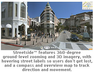
Streetside photography, a feature that debuted almost three years ago with Live Search Maps features 360-degree ground-level zooming and 3-D imagery, with hovering street labels so users don?t get lost, and a compass and overview map to track direction and movement.
Customization tools will also eventually allow people to help enhance Bing Maps by uploading their own images. Eventually, as users upload photos, including exterior and interior photos of locations, Bing Maps will use Photosynth to incorporate these community-generated photos so users will be able to explore the inside of locations such as restaurants, hotels or shops.
Bing Maps now offers a Streetside and enhanced aerial view, giving users the ability to explore what's around them from the street level or from the sky looking down.
The new Bing Maps incorporates several key Microsoft technologies, including Silverlight, a multimedia Web application, and Photosynth, an application from Microsoft Live Labs and the University of Washington that can stitch photos together, turning them into a three-dimensional model.
The new features mean Bing Maps users can now zoom in, out and around; view a location from the street level or from above; seamlessly rotate 360 degrees in one spot; view location-related content while searching an area; and even upload their own synths of a location to be integrated into a map.
In addition to the new features announced this week, Bing Maps continues to acquire its own images via aerial cameras and satellites and will continually add these high-resolution images to its coverage. This focus on the quality of imagery and consistency is more expensive and time-consuming but will inevitably mean a better experience for users, said Stefan Weitz, Bing director.
The new Enhanced Aerial View is a mapping mode unique to Bing that allows users to view an area from the sky using the four cardinal directions. Users can get a taste of directions "as the crow flies," whether zooming over a high-resolution urban area or a non-urban area enhanced by satellite imagery.
The new application gallery also is exclusive to Bing Maps, and according to the Bing Community announcement, will give users the opportunity to develop "geospatially rich data visualization applications." Users can seek out applications such as Travel Webcams and Twitter Maps, which uses Twitter's newly released geolocation tool to map their geographic location as they tweet - even from the Streetside mode.
Streetside photography, a feature that debuted almost three years ago with Live Search Maps features 360-degree ground-level zooming and 3-D imagery, with hovering street labels so users don?t get lost, and a compass and overview map to track direction and movement.
Customization tools will also eventually allow people to help enhance Bing Maps by uploading their own images. Eventually, as users upload photos, including exterior and interior photos of locations, Bing Maps will use Photosynth to incorporate these community-generated photos so users will be able to explore the inside of locations such as restaurants, hotels or shops.