Qstarz Q1300BT GPS
3. Getting started
Review Pages
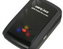
Before using the the BT-Q1300 for the first time, make sure you have fully charged the battery. This can be done either though the the mini USB cable, the travel charger, or car the power adaptor.
Charging typically takes about 1 hour. When the Power LED is Red, the battery needs to be recharged. When the Power LED is Green, the battery is under charging mode and finally when the Power LED is blinking, the battery is fully charged.
To power on the device, press the power button and hold it down for 4 seconds. The same procedure applies when you need to power it off. In order to pass to logging mode, press the power button and hold it for additional 2 seconds (device is already ON). Once the logging mode is active, the LOG status LED (blue) will start blinking . Press power button and hold it for 2 seconds again to disable the log mode. The blue LED will be off and the device will stop logging. Once you are in LOG mode, press the power button once again to log your favorite Point of Interest (POI).
Another neat feature of the Qstarz Q1300 model is the "Auto On/Off" function (Power saving mode). This will make the device automatically enter the sleeping mode after the Bluetooth connectivity is turned off, and the Blue LED will flash every 5 seconds.
But even under the power saving mode, the device will automatically turn on as soon as it detect Bluetooth connectivity. Then the blue LED will start flashing every 2 seconds and the GPS Orange LED will also be active.
Similar power/memory saving functions are supported under the Auto "Log On/Off". Under the Log mode, the device will automatically stop logging when the GPS is not fixed. As soon as the GPS is fixed again, the BT-Q1300 will start to log.
In order to take advantage of the Geotagging features and Google maps, you have to download the latest version of QStarz Travel Recorder (v4.20). In sort the software has:
- Double software included with built-in Google Map, multi-language support, and visualization UI
- Provide PC Utility V3 allowing you to further detailly configure the device
- Provide PC Utility V4 with built-in Google Map and visualization UI for users to easily manage their travel
- Auto track split function helps you organize your travel path
- Support Track Edit function allowing you to remove unnecessary waypoints
- Active NMEA protocol VTG / GLL manually via Qstarz setup tool
- Backup your travel record as GPS / PLT / CSV / NMEA / Google Earth file format
- Draw your navigation path immediately on Google Earth as default
- Support GeoTagging function for digital photo and generate KMZ file easily
For our tests, we used the latest version of the software (v4.20):

Under the configuration panel you can set autoscan for the GPS and the GPS logging setting (car, bike, pedestrian) and of course the log criteria (time, meter, km/h). A progress bar indicates the current utilization of the memory (%).

Connecting with the GPS is done automatically and you can include several tracks to display, edit, etc..

The user manual include a detailed explanation of all the functions of the Qstarz Travel Utility. Overall we have to congratulate Qstarz for the well-designed software and the overall usability/functionality it provides.
Review Pages


